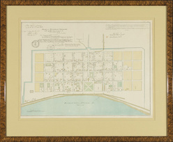
 | | An 1888 map of New Orleans titled Plan de la Nouvelle Orleans; image credit on full record. |
|
Find Current Values for your Antiques!
Map; New Orleans, Plan de la Nouvelle Orleans, 1888, Hand Colored, 19 inch.
Map of the "City of New Orleans", "Plan de la Nouvelle Orleans", 1888, hand-colored, after the original from 1731.
14 in. x 19 in., framed.
p4A Item F7900225
|
Category: |
ephemera |
|
Origin: |
Louisiana |
|
Type: |
maps, globes & charts |
|
Year: |
1888 |
Learn more about this item:
 |
Auction Sales History |
|
Pre-Sale Value |
 |
Condition |
 |
|
Provenance |
|
Reference Notes |
|