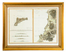
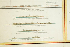
A French hand colored engraved map of Easter Island and Cook's Bay; image credit on full record.
image credit on full record.
image credit on full record.
Find Current Values for your Antiques!
Map; French, Easter Island & Cook's Bay, 1786, Engraving, Hand Colored, 34 inch.
A French map of Easter Island, hand-colored engraving on laid paper dated 1786. "Plan de l'Ile de Paque" and "Plan de la Baie de Cook" (Cook's Bay).
... [more detail available via subscription]