Prices for Antiques

A pair of Bigot D-Day Coxswain Navigational Charts for Omaha Beach-East and Omaha Beach-West; image credit on full record.

Find Current Values for your Antiques!

Nautical Chart (2); D-Day Coxswain Navigational Chart, Omaha Beach East & West, 1944, 22 inch.

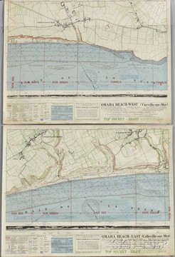
Two Bigot D-Day Coxswain Navigational Charts, 1944, two charts, Omaha Beach-East and Omaha Beach-West, documenting water depths and map of seaside tow... [more detail available via subscription]

p4A Item F7996250
Category:  nautical    Origin:  France
Type:  charts & log books    Year:  1944

Learn more about this item:

Auction Sales History
Pre-Sale Value
Condition
Provenance
Reference Notes

Find Current Values for your Antiques!

Enter keywords to describe your antique

Refine your search by category and type