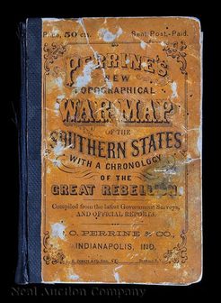
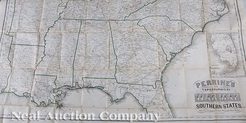
 | | A Civil War Era Map of the Southern States by Charles O. Perrine; image credit on full record. |
 | | image credit on full record. |
|
Find Current Values for your Antiques!
Map; Perrine (Charles), Perrine's New Topographical War Map of the Southern States, 1833, Folding Pocket, 36 inch
Civil War Map, Perrine, Charles O., "Perrine's New Topographical War Map of the Southern States", Indianapolis, Indiana / Buffalo, Jewett & Co., New Y... [more detail available via subscription]
p4A Item F7955818
|
Category: |
ephemera |
|
Origin: |
Indiana |
|
Type: |
maps, globes & charts |
|
Year: |
1863 |
Learn more about this item:
 |
Auction Sales History |
|
Pre-Sale Value |
 |
Condition |
 |
|
Provenance |
|
Reference Notes |
|