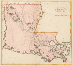
 | | A Mathew Carey 1814 Map of Louisiana; image credit on full record. |
|
Find Current Values for your Antiques!
Map; Carey (Mathew), Louisiana, 1814, Hand Colored Engraving, 17 inch.
Mathew Carey, "Louisiana", London, 1814, hand-colored map from Carey's General Atlas, one of the earliest maps of Louisiana to appear in an atlas.
[more detail available via subscription]
p4A Item F7942383
|
Category: |
ephemera |
|
Origin: |
England |
|
Type: |
maps, globes & charts |
|
Year: |
1814 |
Learn more about this item:
 |
Auction Sales History |
|
Pre-Sale Value |
 |
Condition |
 |
|
Provenance |
|
Reference Notes |
|