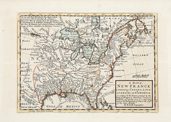
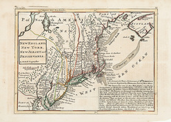
 | | A Pair of Maps by Herman Moll showing New France and the Northeastern United States; image credit on full record. |
 | | image credit on full record. |
|
Find Current Values for your Antiques!
Map (2); Moll (Herman), New France & Northeastern United States, Hand Colored, circa 1725, 11 inch.
Herman Moll, "A Map of New France Containing Canada, Louisiana...in Nth. America", London, 1717; and "New England, New York, New Jersey and Pensilvani... [more detail available via subscription]
p4A Item F7942425
|
Category: |
ephemera |
|
Origin: |
England |
|
Type: |
maps, globes & charts |
|
Year: |
1717 - 1729 |
Learn more about this item:
 |
Auction Sales History |
|
Pre-Sale Value |
 |
Condition |
 |
|
Provenance |
|
Reference Notes |
|